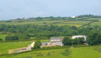
 The majority of the area is the Carboniferous Crackington formation of shale, mudstones and inter-bedded sandstones. A band of Lower Carboniferous slates with thin limestone and shale runs north west/south east and appears to define and produce higher ridges and small isolated hills. Soils are shallow hard rock soils on higher ground to the north and alluvial soils in the valleys.
Land cover is dominated by farmed land of improved grassland/pasture with arable Woodland prominent in places, particularly in and around the valleys and is a mixture of broadleaved, coniferous and mixed woodland. Small areas of wetland and rough ground occur along the valleys. Pasture is the dominant land use both as dry permanent pasture on higher land and wet meadow pastures on the river floodplains.. The wet clay soils of the valleys and valley sides are influential in the distribution of pasture and arable land, and wetland habitats occur in many valley floors. Medieval enclosure is dominant with a significant proportion of post medieval enclosure, often on higher ground. Many of the coniferous woodland and mixed woodland plantations are managed commercially.
 The earliest mention of the village is in the Domesday Book of 1086, when Whitstone was called ‘Witestan’, and thanks to William I, was held by Ralph from the Count of Mortain. The Witestan area, called a “hundred” was 12 acres, holding 8 cattle, 8 pigs, 40 sheep and 40 goats: from this time one of the houses in Whitstone still remains and is still inhabited. (Wikipedia)
In the 19th century, the parish was called Whitstone. There were around 500 villagers, and the village had its own ‘Post Office’, and the entire parish comprised around 4,000 acres (16 km2), with part of the Bude Canal passing through the parish.
Mr Edward Mucklow a Lancashire born man who purchased about seven thousand acres of Land in Devon and Cornwall in the 1870’s and who had a home in Whitstone was a much respected ‘Squire’ and held in high esteem by his tenants and the local population.
 In 2006, the village had the most businesses it ever had. Over the last ten years or so, the village has grown and now has around nine businesses. Some of these are big nationally, some are just local and some are just known within the village, selling homemade items from home.
Whitstone Village Stores opened in the 1980s, and has changed hands a couple of times, with closures during the handovers. After a long closure, it was opened again in 1996 with a brand new interior. The shop has changed hands a number of times since then.
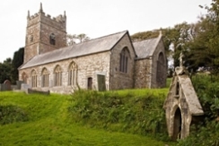 This pretty little church with its adjacent holy well claims for Patron St. Anne, although St Nicholas appears in official record as early as 1309. Of the Norman church two relics survive in the Norman font and the porch doorway, the latter of course, being not in its original position. The curious little window, or squint, communicating between the porch and south aisle is of great interest if of genuine antiquity, but its purpose is not easy to determine. As usual, the church was rebuilt in the 15th century and a western tower added to it.
Richard Buvyle, rector of Whitstone, died in 1358, slain either by his own hand or “emulis suis”. He was doubtless buried at a cross-roads. Rumours had it that he was a saint, and some remarkable cures having taken place at his grave, the body was translated to the church. meanwhile the cult of this new saint had taken hold of all North Cornwall and Devonshire. Banks of people kept nightly vigils at the first place of his burial, saying prayers for his soul. These, with the friends who brought them victuals, converted the place into a regular fair, with the inevitable result of what Bishop Grandisson Called “Commessaciones ebrietates et conventicule inhoneste, illicita et nepharia que non decet exprimere”. The Bishop took a firm line. He ordered the cultus to cease until due enquiry into the alleged cures had been made. In 1361 a certificate of 10 cures performed on five men and five women was sent to him by a jury consisting of three vicars, three curates, and six laymen, specially summoned at Week St Mary for the purpose. Four were effected at the original grave and six in the church. They are certainly very remarkable, one being of a lunatic lady from Northam, who, being brought bound to the church, strove to lacerate the wax candles with her teeth and to throw down the images. Being, however, cured on the spot her protestant fury abated and her next visit to Whitstone was one of devout gratitude, pilgrimage and prayer. The matter, however, seems to have died a natural death, for we hear no more of it. In 1779 William Score, rector since 1736, reported to the Bishop “as to dissenters in my parish, there have been some disguised Papists as I am told who call themselves Methodists.” A Chapel of Holy Trinity was licensed in 1429, possibly an aisle in the church.
From Parochial history of Cornwall
The church has its own cemetery, but also has a separate cemetery for those people who do not attend the Church which was given to the village in 1926 by Mr S O Ham.
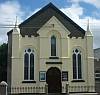 The Methodist Chapel is in the centre of the village, with a private car park on the opposite side of the road. The first Bible Christian chapel was opened at Boot in 1835. James Thorne preached on the foundation stone of the present church in 1863 and it was opened in the following year by Frederick W Bourne. Thorne was the leader of the Bible Christians through most of their ninety two year history, and Bourne for the last thirty years of the denomination.
From Methodism in Cornwall
There was a bible Christian chapel in the village at Boot which was the old name for the centre of the village. The Bible Christain chapel, know as Ayres chapel closed many years ago it was used as the Methodist Sunday school until 1950’s and then was sold. A local builder JRJ Rees bought it and used it as a store for many years. After his death it was sold and a change of use applied for and it is now being converted into a house under private ownership.
Maggie Stanbury (2016)
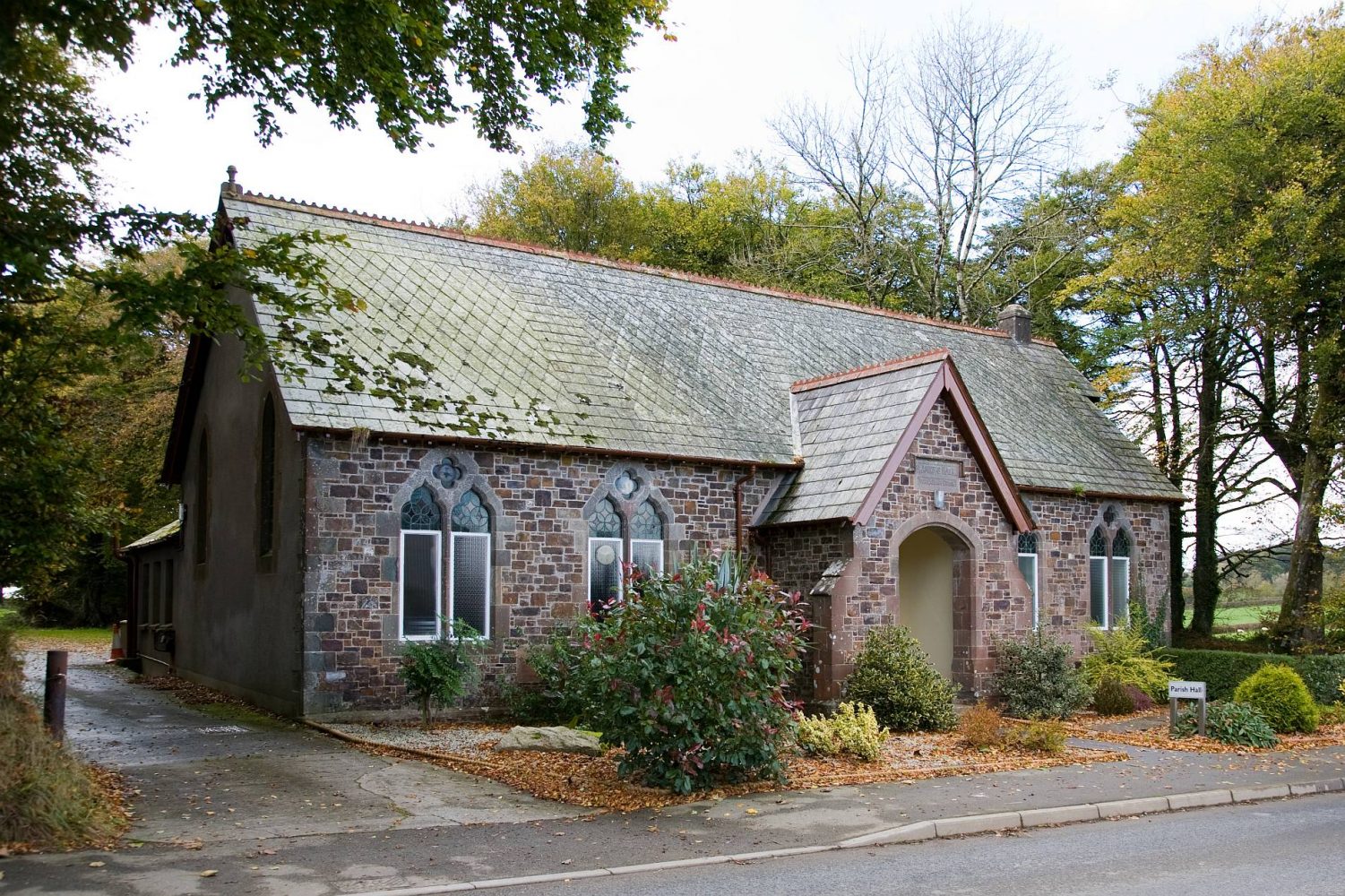
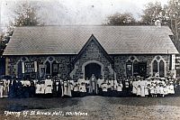 The Hall was dedicated to the memory of Rev. Robert Hawker Kingdon who was Rector of this parish for 44 years and who died at Christmas 1908. The foundation stone for the new Hall was laid by his grandson Robert C. Hawker Kingdon on 9th September 1909 and the building was officially opened on 9th September 1910 when there was a procession, led by a band, from the Rectory to the Hall followed by a High Tea. The original photograph of this event shows a large group of parishioners standing in front of the Hall in all their finery. An enlargement of this picture now hangs in pride of place in the main Hall.
From a talk on the history of the hall given by Mervyn Collins on 9th September 2010
 Church history and records, population from 1801 to 2001 and many more facts and statistics.
What’s in a name?
 If anyone rings us and wants our address nine times out of ten they will ask ‘How do you spell Wadfast?’ Wadfast is an old Anglo Saxon name and was spelt Wadefeste in 1086. The Wade part either refers to someone’s name Wada or the English word wade meaning a ford. The second part fast meaning a stronghold or a secure place, thus the name either means the stronghold of a person called Wada or the stronghold of a ford. On an old map there were two fords, one at the bottom of the Hill opposite the Entrance to the woods and one further along our lane which leads to fields known as Waddons. Similarly Buckfast in Devon seems to mean the Bucks safe place. Lower Wadfast is mentioned as a Manor in the Doomsday Book, coming down the hill from the village known as Briskey Down or it’s former name Buskey Down there is a sycamore tree on the left hedge, but referring back to ‘Martyn’s Map’ 1748 this is roughly the position of the Old Manor House. The Doomsday entry records that it was held in 1086 by Hamelin from the Count; Siward held it before 1066, and paid tax for half of the land ( yes they paid taxes then!!) With land for 6 ploughs, 3 slaves, with 1 villagers and 5 smallholders. 15 acres of woodland, 100 acres of pasture. The value formerly was 20shillings with 8 cattle, 30 sheep, 6 pigs and 15 goats!! No intensive farming then! There is another settlement shown between Lower and Higher Wadfast until maps in 1748 but this does not appear on any later maps. On the RPA (Rural Payment Agency to give them their correct title, we could think of others!!) updated maps it shows a place of heritage status, an old settlement along Waddons Lane, it is easy to see the remains of two or three hedges there. In 3 of our fields it is possible to see this when the sun is at the right angle, or this winter, where the snow would melt first, shows the signs of the old Anglo -Saxon ploughing method known as Ridge and Furrow where it is possible to see slight inclines and indents in lines approximately 4 metres (13 feet in old money!) apart. Going across with a tractor at speed is a very bumpy ride. Obviously these fields have never been ploughed with a tractor pulled plough. This is by no means unique to Wadfast there must be a lot of fields showing the same characteristics, look out for them as you travel around the countryside. Has anyone else researched the history of their property?
John Stanbury